
Each of these mini-tutorials can be done in the order shown below, but this is not entirely necessary. The lessons are intended as a resource that you can use in whatever order suits you best. When you click on any of the links below, the interactive video will start in its own new tab in your browser.
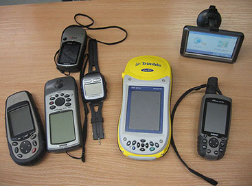
Mini-tutorial #1—Collecting geographic locations with a hand-held GPS receiver
This mini-tutorial will walk you through the process of collecting x, y coordinates (waypoints) with a hand-held GPS receiver unit.
This exercise is simulated using an interactive widget. It also covers tips for increasing accuracy and recommended settings for the unit.
Scenario:
You have a hand-held GPS receiver unit and would like to be able to record the exact locations of a set of survey locations.
You may not be familiar with the way a GPS system works, and may not be aware of hindrances to collecting points with maximum accuracy. Also, you may not understand the unit’s settings and why they are important. As a result, you don’t understand your results, or you fail to collect useful data points. This simulated hands-on practice will help you learn best practices when collecting data in this manner.
Learning Objectives:
- Learn to collect GPS coordinates (waypoints) using a simulated hand-held receiver
- Learn how to increase accuracy
- Learn recommended GPS receiver settings and their importance
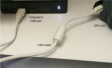
Mini-tutorial #2: Transferring WayPoints from a GPS Unit into a QGIS Point File
This mini-tutorial will help you take a hand-held GPS receiver unit containing coordinate (x, y) data, plug it into your computer, bring in a file containing the GPS coordinates (also known as “waypoints”) to QGIS (a freely available geographic information system—see information about the software in the FAQ section of this website), check the locations for accuracy, and save the map file for future use in QGIS.
Scenario:
You have a GPS unit loaded with GPS location data that someone collected when they took the unit into the field to do site visits. You want to view that data on a road map in QGIS and use the map file later.
You may not be aware of the importance of checking the format in which the data were originally collected, the hardware and software needed for the task, or the procedure to be followed in QGIS. This tutorial walks you through these steps and then lets you try them on your own. It also gives you troubleshooting tips for the most common reasons why things go wrong.
Learning Objectives:
- Take a GPS unit containing coordinate (x, y) data and plug it into your computer
- Bring in a file containing the GPS coordinates (also known as “waypoints”) to QGIS
- Check the locations for accuracy against a background map
- Save the file for future use in QGIS
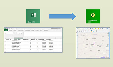
Mini-tutorial #3: Transferring coordinate data from a spreadsheet to a map in QGIS
This mini-tutorial will help you examine an Excel spreadsheet containing coordinate (x, y) data, make sure it is properly formatted, import the data to QGIS and plot the locations, check the locations for accuracy, and save the coordinate location file for future use in QGIS.
Scenario:
You have an Excel spreadsheet of all of your (x, y) locations and waypoint IDs, compiled from some GPS data files on your computer. You would like to view all the locations on a map and be able to use the GIS file later or share it with other GIS users.
You may not be familiar with Cartesian coordinate systems or of the importance of checking the format in which the data were originally collected. Nor do you know the correct method of formatting these points in a spreadsheet, or the procedure to follow when you import the coordinates into QGIS. The tutorial gives you the background knowledge necessary for you to understand the scenario, walks you through these steps, and then lets you try them on your own. The tutorial also gives you troubleshooting tips for the most common reasons why things go wrong.
Learning Objectives:
- Become familiar with Cartesian coordinate systems
- Learn how to properly format a spreadsheet containing geographic coordinates
- Learn how to import data from Excel into QGIS
- Practice checking locations for accuracy on a map
- Practice saving coordinates to a file for future use in QGIS
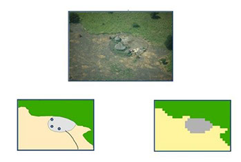
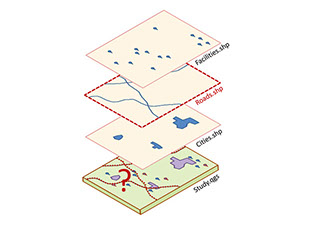
Mini-tutorial #4: Recognizing common geographic data files and working with shapefiles.
This mini-tutorial reinforces the differences between raster and vector files for new GIS users, and provides a hands-on introduction to working with “shapefiles”—the most common type of geographic data file.
You will practice transferring a shapefile using a “zipping” (file compression) program, and also learn how to receive such a package and “extract” the files.
Scenario:
You aren’t familiar with geographic data files. You don’t understand what a “shapefile” is or what you can do with it. You’re just getting started in GIS, and need help with basic file management.
Learning Objectives:
- Master distinguishing between raster and vector files
- Identify and distinguish shapefiles and their essential components
- Practice selecting the essential components and zipping to portable format
- Practice extracting a shapefile from a zipped package for use in QGIS
Mini-tutorial #5: Working with QGIS project files; handling missing data layers.
This mini-tutorial distinguishes shapefiles and project files and how the project file references a shapefile.
You’ll practice resolving the most common error messages encountered in opening a QGIS project file (“missing data layers”); you’ll practice fixing “broken links” to missing data; and you’ll practice creating a folder that contains all layers and the project file copied to one place, ready for zipping and transport.
Scenarios:
- You’ve received a QGIS project file, and when you open it, you see this error message: “missing data layers.”
- You’d like to send a map file to colleagues and let them look at and edit the data layers in their own geographic information systems.
Learning Objectives:
- Distinguish shapefiles and project files
- Practice resolving the most common error message encountered when opening a QGIS project file: “missing data layers”
- Practice fixing “broken links” to missing data
- Practice creating a folder that contains all layers and the project file copied to one place, ready for zipping and transport
- Be aware of a plugin—Qpackage—that can copy all project layers and the main file in one location for easy transport
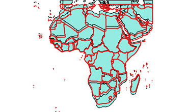
Mini-tutorial #6: Coordinate systems and projections: how do I get all my data layers to line up?
This mini-tutorial will introduce new GIS users to the concept of projected and unprojected coordinate systems and explain the most common coordinate reference systems.
You’ll practice aligning layers according to projections, so that data will display properly when used to create maps. You’ll also master using a projected coordinate system in order to make measurements in kilometers and do many kinds of spatial analysis.
Scenarios:
- You imported a shapefile that does not seem to line up with the other map layers.
- You have a data layer with an unknown coordinate system.
- You want to do some spatial analysis, and need the measurements to be in kilometers, but the map is displaying in degrees.
Learning Objectives:
- Distinguish projected vs. unprojected geographic data files
- Identify a file’s coordinate reference system (CRS)
- Explain the characteristics of major projections
- Practice changing projections/setting the CRS